
Urbanisation
( Sociology Optional)
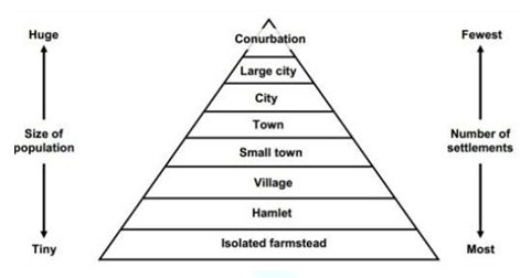
Classification of Settlements
"Settlement is man's first step towards adapting himself to his environment.” - Perpillou.
Settlements are classified on the basis of economic activities
- Rural settlements: people are mostly engaged in agriculture and allied activities (livestock keeping, dairy farming, poultry, forestry, fisheries, and mining). A village has a community bond.
- Urban settlements: residents are engaged in non-agricultural activities (industries, services, etc). The city life is heterogeneous and alien.
On the two sides of a spectrum, the rural communities stand at one extreme and the large metropolis at the other. Between the two are all grades of urbanization. Hence there is increasing emphasis on rural urban continuum.
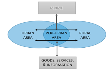
A region may be divided into three wide parts from settlement point of view:
- Urban areas,
- Rural-urban fringe, and
- Rural areas
Urban area
- It a large compact (nucleated) settlement, predominated by secondary and tertiary functions.
- It is a human settlement with high population density and infrastructure of built environment.
- It is categorized as cities, towns, conurbations, suburbs etc.
- Large compact (nucleated) settlement in which most of the work-force is engaged in the secondary and tertiary sectors.
- No uniform criterion to define an urban place.
- There is some degree of arbitrariness in the definition of urban and rural places.
- Generally defined on the basis population size, density, occupations, and the type of local government.
Rural area
- Rural area or countryside is a small settlement of low population density.
- It includes villages and hamlets.
Suburbs
- A suburb is an area of mixed urban land use pattern, existing either as part of a city or urban area.
- The people living in the suburbs identify themselves with the metropolitan city. The postal and telephone departments consider the suburbs as part of the metropolitan.
- High speed transport and transit corridors are prerequisite for a suburb. People living in suburbs commute daily to the city. These are in fact dependent upon the city for most services. e.g. education, health and shopping.
Exurb
- The term was coined by Auguste Comte Spectorsky, in his book The Exurbanites (1955).
- It is used to describe the ring of prosperous communities beyond the suburbs. Most exurbs serve as commuter towns, but most commuter towns are not exurban.
Satellite Town
- It is used by urban planners to house the overspill population, which refers to a town in the vicinity of a large city.
- It is a discrete, self-contained entity, theoretically independent of the central city.
- People may or may not be commute to the metropolitan. If not commute, it may emerge as self-contained township.
Characteristics
- These are small or medium-sized cities near a large metropolis.
- These predate the metropolis suburban expansion, and hence act as counter magnets.
- These are partially independent from the metropolis economically and socially.
- These are physically separated from the metropolis by rural territory or by a major geographic barrier such as a large river.
- Satellite cities should have their own independent urbanized area, or equivalent
- have their own bedroom communities
- It has own industrial and historic base, a traditional downtown or CBD
- Satellite towns neither receive metropolitan services, nor do they pay taxes to the city.
|
Satellite towns |
suburbs |
|
Presence of own industrial and employment base. |
Absent |
|
Existence of own historical and cultural background. |
Absent |
|
People may or may not commute to metropolitan. |
People commute daily.
|
|
Generally located outside the rural urban fringe. |
Generally integral part of the rural urban fringe. |
|
Independent municipal government. |
Part of metropolitan. |
|
e.g. Faridabad, Gurugram |
e.g. Shakarpur, Shahdara |
Twin cities
- Twin cities are a special case of two cities that are founded in close geographic proximity, which grow into each other over time, losing most of their mutual buffer zone.
- If population of a city becomes more than twice of a threshold, twin city will develop.
- It has presence of own industrial and historical base. People do not commute to metropolitan.
Dormitory town
- It is a town which houses the residents who normally work elsewhere, but in which they live, eat and sleep.
- It usually grows from a rural settlement. It has little commercial or industrial activity base.
- Dormitory town is a British concept. It is also known as exurb, bedroom community (Canada), bedroom town (USA).
Secondary city
- Professor Dennis Rondinelli coined the term secondary city in 1980s.
- A secondary city often follows after a primate city and can be seen in the urban hierarchy. E.g. Sub-national cities.
- It is relatively less famous outside its country or region. It assumes logistic, administrative or economic function outside large metros.
- According to the World Bank, secondary Cities make up almost 40% of the world cities population. Nearly two-thirds of these are located in Africa and Asia:
Edge city
- The term originated in the USA. The term was popularized by Joel Garreau in his book ‘Edge City: Life on the New Frontier’.
- Edge city is similar to secondary CBD or downtown. Garreau writes that edge cities' development proves that “density is back!”
- Concentration of business, shopping, entertainment etc. outside a traditional CBD, in what had previously been a residential or rural area.
- Transport, automobile, land value, shadow government etc. are main factors.
- These develop near expressway or freeway.
Green belt
- It is a policy and land use designation used in land use planning to retain areas of largely undeveloped, wild, or agricultural land surrounding or neighbouring urban areas. Similar concepts are greenways or green wedges which have a linear character and may run through an urban area instead of around it.
- g. Adelaide's CBD is completely encircled by the Adelaide Parklands, Ottawa Greenbelt – Surrounds the Canadian capital Ottawa;
- A greenway is "a strip of undeveloped land near an urban area, set aside for recreational use or environmental protection". However, the term can in fact include "a scenic road". Greenways resemble linear parks, but the latter are only found in an urban and suburban environment. In Australia, a linear park along the coast is known as a foreshoreway.
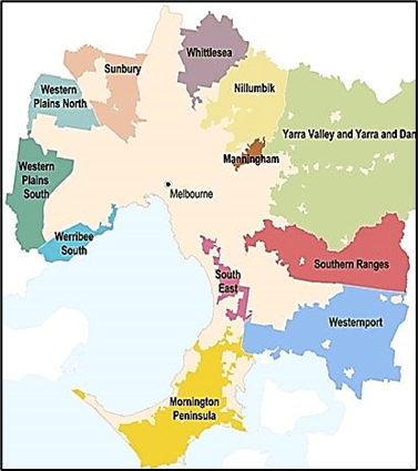
- Green wedges: The non-urban areas that lie outside the Urban Growth Boundary are known as green wedges.g. 12 designated green wedge areas ring around the Melbourne city like Mornington Peninsula coastline, to the open basalt plains of the west, to the highly scenic countryside of the Yarra Valley.
- The term green wedge was formally recognised in the ‘Melbourne 2030: Planning for Sustainable Growth metropolitan strategy’.
City region
- It is a concept used by economists and urban planners to denote a metropolitan area and its hinterland, usually divided administratively but with shared resources and markets.
- It originated in a British policy context through Derek Senior's Memorandum of Dissent in the 1969 Redcliffe-Maud Report.
- City region is a term in use since about 1950 by urbanists, economists and urban planners to mean a metropolitan area and hinterland, often having a shared administration.
- Typically, it denotes a city, conurbation or urban zone with multiple administrative districts, but sharing resources like a central business district, labour market and transport network such that it functions as a single unit.
Historical Background of urbanization in India
The Indian sub-continent experienced at least five phases of urban growth:
- During the bronze age Harappan civilization (fourth-second millennium B.C.)
- Early historic urban centres of the iron age (c. sixth century B.C. to the end of the third century A.D.)
- Early medieval towns and cities (c. eighthlninth to twelfth centuries A.D.)
- During colonial times
- Post-colonial era
India's urban pattern is a mosaic of segments belonging to the pre-colonial, colonial and post-colonial periods (Rajbala and King, 1976)
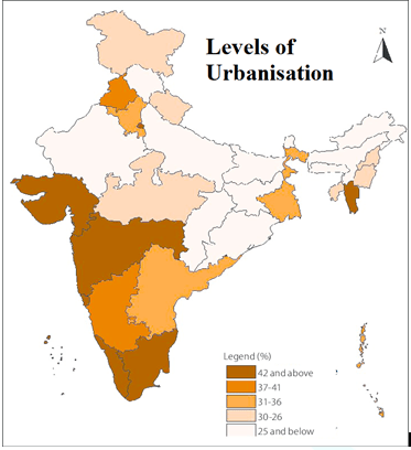
Level of urbanization in India
It can be understood based on the census definition of urban places.
The Census of India until 1951 defined an urban settlement as:
- All places with municipality, corporation, cantonment board, and notified areas.
- All other places which satisfy the following conditions:
- Minimum population of 5000.
- Density of population of at least 400 persons per sq km.
- At least 75 per cent of the male working population engaged in non-agricultural economic activities.
The Census of 1981 incorporated livestock, forestry, fishing, hunting, plantation and orchard as agricultural activities.
Places having distinct urban characteristic and civic amenities like industrial area, railway colonies, tourist places, health resorts etc. were regarded as urban places at the discretion of the Director General of Census Operation in consultation with the state government.
Limitations:
- Element of arbitrariness in the definition; the discretion could be subjective and non-scientific.
- The aggregate urban population in each census was based on discretion of Census Officials.
- The decisions about the ‘big village’ and ‘small towns’ rests largely on the discretion of Census Superintendent.
- The census definition also laid emphasis on urban characteristic and civic amenities. But it is discretionary and there is no specific list available.
- The population density of 400 is unrealistically low in the Indian context. Many states have rural population density higher than this. A much higher value (around 1000) would be more appropriate.
The Census Department of India has classified urban places under six categories:
- Class I: Population of 100,000 and above.
- Class II: Population of 50,000 to 99,999
- Class III: Population 20,000 to 49,999
- Class IV: Population 10,000 to 19,999
- Class V: Population 5000 to 9999
- Class VI: Population less than 5000
Theories of Origin of Urban Settlements
There are four group of models for origin and growth of urban settlements.
1. Ecological Models
- These models associate urbanism with the ‘surplus’ production of food in hydraulic societies, which were based on large-scale irrigated systems.
- An agrarian society based on efficient irrigation systems had surplus production.
- The effective management of these irrigation works involves an organizational structure. In consequence, those who control hydraulic network, hold the supreme political power.
- It enforced an inordinately powerful control by the state over its subject population. In effect, it was a state stronger than society.
- As per Wittfogel, “the state occupied an unrivaled position of operational leadership and organizational control in such systems”.
- The state apparatus, thus, took the form of a hydraulic bureaucracy. A hydraulic society grows into large settlements.
- It mobilized labour and created large settlements, which ultimately created urban settlements.
‘Oriental Despotism: A Comparative Study of Total Power’
- It is a book of political theory and comparative history by Karl August Wittfogel.
- The book explains the despotic governments in "Oriental" societies, where control of water was necessary for irrigation and flood-control.
- Managing these projects required large-scale bureaucracies, which dominated the economy, society, and religious life.
- This despotism differed from the Western experience, where power was distributed among contending groups.
- The book argues that this form of "hydraulic despotism" characterized ancient Egypt and Mesopotamia, Hellenistic Greece and imperial Rome, the Abbasid Caliphate, imperial China, the Moghul empire, and Incan Peru.
2. Economic Models
- These models focus on changing forms of economic integration.
- Mostly these focus on the transition from reciprocity to redistribution.
- Most of these models are taken from Polanyi’s Economic anthropology.
3. Cultural Models
- These models examine the formative influence of religion on urban genesis.
- “The religious component is almost alone”. - Wheatley (1971).
- David Emile Durkheim studied the role of religion in primitive societies.
- According to Durkheim, “The essence of religion in modern society is the same as religion in primitive society.”
- The origin of religion lies in psychological phenomena such as dreams and ghost fear. E.g. animistic view of Herbert Spencer.
- A community at times come together to communicate the same thought and actions. Such an event causes collective effervescence which excites individuals and serves to unify the group. Such unified groups leads to growth of settlements.
- The earliest foci of power took the form of religious centres.
- Religious symbolism provided a framework for social action. It imprinted deeply on the morphology and iconography of ancient city.
4. Politico-military Models
These models typically conceive of the city as both fortress and refuge.
- Many of these models are compatible with the arguments of ‘hydraulic society’ and ‘Oriental Despotism’.
- However, these models justify the decisive importance of military power in creation of a number of cities for the creation of empires.
- These justify the centring of “political and military power first in theocratic and later in monarchical control.” – Giddens, 1981.
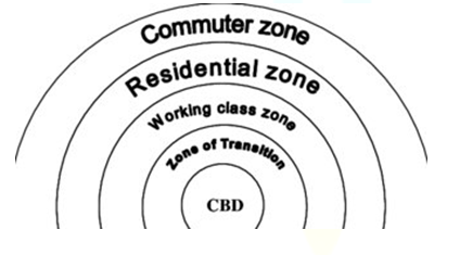
E.W. Burgess’ Concentric Zone Model of Urban Growth
This model was proposed by American urban sociologist, E.W. Burgess (1924, 1927), who based his studies on Chicago city.
Basis
- Concentric zone: There exists a series of concentric zones, each with a distinct land use.
The Theory
- “The growth of a city takes place outwards from its central area to form a series of concentric zone.”
- There are five concentric zones characterized by distinct land use patterns.
|
zone 1 |
CBD (Central Business District) |
· Focus of commercial, social and civic life. · High land value and rent. |
|
Zone 2 |
Transition Zone |
· 1st generation immigrants. · Occupied by lower income groups. · Planned encroachment e.g. slums. · Mixed land use pattern. · Zone of residential deterioration. |
|
Zone 3 |
Zone of Workmen’s Home |
· 2nd generation immigrants, migrated from zone 2. · Planned flats in India. |
|
Zone 4 |
Residential zone |
· Resided by middle and upper middle classes. · Dominated by single families. |
|
Zone 5 |
Commuters zone |
· Extends to the rural urban fringe. · Mostly former villages, converted into dormitory towns. · Large spacing houses. |
Criticism
- Overgeneralisation: Circular shape of CBD is not necessary.
- Overemphasis on tertiary activities neglecting the industrial land use.
- Outward expansion of zone 2 into zone 3 is not explained.
- Major transport routes are ignored.
- Isotopic surface: The topographical factors have also been ignored.
Some prominent traits of urban centers
- Large size of a settlement in terms of area and population.
- Proximity to water resources-river banks, tanks, ring wells, etc.
- Presence or absence of artefacts representing activities of artisans, e.g. axes, chisels, plough-shares, sickles, hoes, crucibles, ovens, furnaces, dyeing vats, molds for beads, seals, sealings, jewelry, terracotta, etc.
- Evidence of coin molds signifying mint towns. The discovery of metallic. money, when listed with the presence of artisans and merchants, certainly lends a clear urban character to such sites.
- Presence or otherwise of luxury goods such as precious and semi-precious stones, glassware, ivory objects, fine pottery etc. The possibility is not ruled out that luxuries of ancient towns might become necessities for superior rural classes of early medieval times.
- Considering the moist, rainy climate of many alluvial plains such as themiddle Ganga plain, baked brick (not just burnt bricks) structures on a good scale assume special importance. Though in Central Asia towns consisting of mud structures are also not unknown.
- Streets, shops, drains and fortifications also give a good idea of the nature of the urban settlement. At several places in the Deccan and elsewhere silos and granaries occur at historical sites, like at Dhulikatt in Andhra Pradesh. Apparently such structures were meant to store surplus foodgrains for feeding.

Urban scenario in India
Background
- In 1.02 billion populations, 285 million or 8 per cent live in the urban areas which comprises of 5,161 towns, an increase of 2.1 per cent in urban population in the 1991 census.
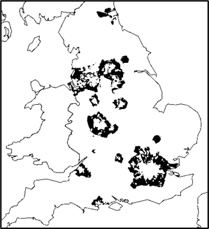
- There is a wide variation among the states in urbanization. Please refer to the map and explain it while writing an answer. You can use following data, if required.
- At one end of the spectrum is the National Capital Territory of Delhi, with 93 per cent of its population living in urban areas.
- At the other end, Himachal Pradesh is the least urbanized state with only 9.8 per cent of its population in urban areas.
- Tamil Nadu is the most urbanized among the larger states with 43.9 per cent urban population, followed by Maharashtra with 42.4 per cent and Gujarat with 37.4 per cent.
- Among the larger states, Bihar has the lowest proportion of urban population (10.5per cent), below Assam (12.7 per cent) and Orissa (14.9 per cent).
- The degree of urbanization in India is among the lowest in the world. United Nation estimates show that 48% population of the world live in urban areas.
India’s current Status
- There are 27 cities with more than one million population, while the Urban Agglomerations (UAs)/Cities with population of more than one millionaire 35 in number.Urban sector contribution to India's Net Domestic Product is estimated to be 50-52%.
- In India, 64.7% of employment in trade, commerce, and financial services; 65% in manufacturing; and 68% in the transport sector-are concentrated in urban areas.
Phases of Urban Growth in India
The trend of urbanisation can be traced from census data. The growth trend is however, not steady. It is divided into three phases. The regional pattern is uneven.
Phase 1: Period of Slow Urban Growth (1881 to 1931)
- Frequent occurrence of natural calamities like drought, floods, famines, epidemics.
- High mortality rate retarded the urban growth of population.
- Average annual growth rate of less than one per cent.
Phase 2: Period of Medium Growth Rate (1931 to 1961)
- Relatively faster pace; 12.2% (1931) to 18.3% (1961).
- Planned period after Independence; new industrial and urban centres were established.
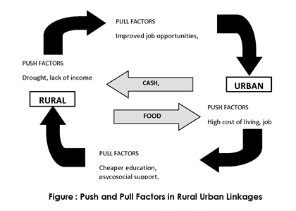
Phase 3: Period of Rapid Urban Growth (1961 to 2011)
- 3 % to 31.16 %
- Presently the country is passing through a phase of rapid urban growth as the rural population is migrating towards the urban centres.
- National average urban growth rate: over 8 per cent.
- Manipur has the highest increase (19%), followed by Nagaland (15%) and Kerala (12%).
- Stunted in Assam, Bihar, J&K, Himachal Pradesh, Odisha, and Sikkim, etc.
Characteristics of Indian cities
- widespread poverty, inadequate urban infrastructure, and environmental degradation.
- The 2001 population census found that although 91% of India's urban dwellers had access to drinking water, only 49.7% of households had tap water on their premises.
- Similarly, only 57.4% of urban households had sanitation facilities on their premises.
- Slums, another highly visible manifestation of urban poverty, housed approximately 40 million people, representing around 14.12% of the total urban population in India in 2001.
- Urban poverty in urban areas has declined pm 52% in 1972-1973 to 23:6% in 1999-2000, but this percentage represents 65 million people who live in absolute poverty.
- Poor urban development management is not only undermining India's ability to deliver quality of life to its citizens, but also constraining potential local, and national economic growth.