
Tectonic Framework of India
Tectonic Framework of India
- Tectonic Framework is the relationship in space and time of ‘subsiding, stable, and rising tectonic elements’ in a sedimentary source area.
- The Indian subcontinent represents more than 5 Ga of geological history spanning from the Archean to Quaternary.
- Surrounded by the Himalayan Orogen, Indian Ocean, Bay of Bengal and Arabian Sea on its north, south, east and west, respectively.
- The exposed Precambrian basement of India comprises four Archean cratonic nuclei welded together by several Proterozoic mobile belts. Proterozoic intracontinental basins that contain mostly undeformed sedimentary successions unconformably overlie the basement.
- The basement rocks are covered in the north along the Himalayan front by thick deposits of the Indo-Ganga alluvium, and in the west central region by the end-Cretaceous Deccan flood basalts.
- Basins related with intra- to inter-continental rifting of the Indian craton viz. the Gondwana Basins and those of the east and west coast record the Phanerozoic history of India from Permian to Cenozoic.
- Since ~55 Ma, the continent-continent collision between the northerly drifting Indian Plate and the Eurasian Plate has guided the development of the structural design of the Himalayan Orogen.
- These tectono-geomorphic processes were responsible for the first order relief structure of the northern part of the Indian subcontinent including the development of the topography of the spectacular Himalayan Orogen and its foreland.

Triple Tectonic division of India
Geologically, India is divided into 3 tectonic regions
- Peninsular Plateau region – It also includes the Shillong Plateau and the Kutchch Kathiawar region (Outliers)
- Extra-peninsular region – the mountainous region of Himalayas.
- The Himalayas are young, weak and flexible in their geological structure, unlike the rigid and stable Peninsular Block.
- Consequently, they are still subjected to the interplay of exogenic and endogenic forces, resulting in the development of faults, folds and thrust plains.
- These mountains are tectonic in origin, dissected by fast-flowing rivers which are in their youthful stage.
- Various landforms like gorges, V-shaped valleys, rapids, waterfalls, etc. are indicative of this stage.
- The Indo-Gangetic Plain: It is located between the above two.
There are 2 minor divisions:
- The Coastal Plains (Eastern and western)
- The Islands (Lakshadweep and Andaman and Nicobar)
Plate Tectonics of India
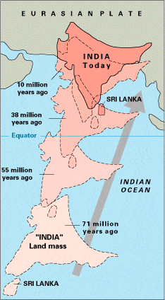
- The Indian Craton was once part of the supercontinent of
- At that time, what is now India's southwest coast was attached to Madagascar and southern Africa, and what is now its east coast was attached to Australia.
- During the Jurassic Period about 160 Ma (ICS 2004), rifting caused Pangaea to break apart into two supercontinents, namely Gondwana (to the south) and Laurasia (to the north).
- The Indian Craton remained attached to Gondwana, until the supercontinent began to rift apart about in the early Cretaceous, about 125 million years ago (ICS 2004).
- The Indian Plate then drifted northward toward the Eurasian Plate, at a pace that is the fastest known movement of any plate.
- It is generally believed that the Indian Plate separated from Madagascar about 90 Million years ago (ICS 2004), however some biogeographical and geological evidence suggests that the connection between Madagascar and Africa was retained at the time when the Indian Plate collided with the Eurasian Plate about 50 Million years ago.
Tectonic Evolution
- The earliest phase of tectonic evolution was marked by the cooling and solidification of the upper crust of the earth's surface in the Archaean Era (prior to 2.5 billion years) which is represented by the exposure of gneisses and granites especially on the Peninsula.
- These form the core of the Indian Craton.
- The Aravalli Range is the remnant of an early Proterozoic orogen called the Aravali-Delhi Orogen that joined the two older segments that make up the Indian Craton.
- It extends approximately 500 kilometres (311 mi) from its northern end to isolated hills and rocky ridges into Haryana, ending near Delhi.
- Minor igneous intrusions, deformation (folding and faulting) and subsequent metamorphism of the Aravalli Mountains represent the main phase of orogenesis.
- The erosion of the mountains, and further deformation of the sediments of the Dharwarian group (Bijawars) marks the second phase.
- The volcanic activities and intrusions, associated with this second phase are recorded in the composition of these sediments.

The viscous flow patterns in a hotter lithosphere-asthenosphere system, the outcome of which is that perhaps mafic lower crustal layers flow/delaminate downward, rather than subducting in today's sense. A key difference would be the metamorphic/hydration history of the mafic "drip" vs. "slab"
- Early to Late Proterozoic (2.5 to 0.54 billion years) calcareous and arenaceous deposits, which correspond to humid and semi-arid climatic regimes, were deposited the Cuddapah and Vindhyan basins.
- These basins which border or lie within the existing crystalline basement, were uplifted during the Cambrian (500 Ma (ICS 2004)).
- The sediments are generally undeformed and have in many places preserved their original horizontal stratification.
- The Vindhyans are believed to have been deposited between ~1700 and 650 Ma (ICS 2004).
- Early Paleozoic rocks are found in the Himalayas and consist of southerly derived sediments eroded from the crystalline craton and deposited on the Indian platform.
- In the Late Paleozoic, Permo-Carboniferous glaciations left extensive glacio-fluvial deposits across central India, in new basins created by sag/normal faulting.
- These tillites and glacially derived sediments are designated the Gondwanas series.
- The sediments are overlain by rocks resulting from a Permian marine transgression (270 Ma (ICS 2004)).
- The late Paleozoic coincided with the deformation and drift of the Gondwana supercontinent.
- To this drift, the uplift of the Vindhyan sediments and the deposition of northern peripheral sediments in the Himalayan Sea, can be attributed.
- During the Jurassic, as Pangea began to rift apart, large grabens formed in central India filling with Upper Jurassic and Lower Cretaceous sandstones and conglomerates.
- By the Late Cretaceous India had separated from Australia and Africa and was moving northward towards Asia.
- At this time, prior to the Deccan eruptions, uplift in southern India resulted in sedimentation in the adjacent nascent Indian Ocean.
- Exposures of these rocks occur along the south Indian coast at Pondicherry and in Tamil Nadu.
- At the close of the Mesozoic one of the greatest volcanic eruptions in earth's history occurred, the Deccan lava flows.
- Covering more than 500,000 square kilometres (193,051 sq mi) area, these mark the final break from Gondwana.
- In the early Tertiary, the first phase of the Himalayan orogeny, the Karakoram phase occurred. The Himalayan orogeny has continued to the present day.
Due to continental drift, the India Plate split from Madagascar and collided with the Eurasian Plate resulting in the formation of the Himalayas.