
Evolution of the Himalayas
Evolution of the Himalayas
- The Himalayas are termed geographically as the young fold mountains.
- Ironically the world’s tallest mountain ranges are all young collisions i.e., formed in recent geological time scale (10- 25 million years) eg. Himalayas, Rockies etc. while old mountains are shallow hills with reduced heights due to continuous erosion since eras in the geological timescale. (200 million years ago) eg. Urals, Aravallis.
- In short, Formation of Himalayas is mainly the result of plate tectonics.
- As per plate tectonic theory various type of landforms form resulting from plate convergence/divergence in plate boundaries.
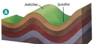
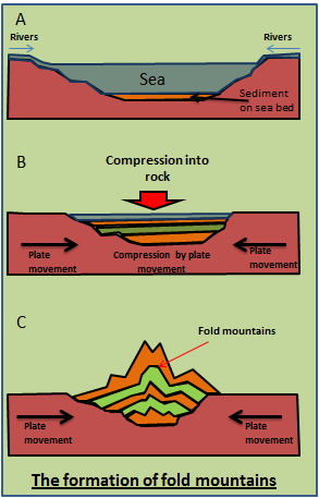
- Fold mountains are the consequence of convergent plate boundary of 2 continental plates creating Synclines and Anticlines.
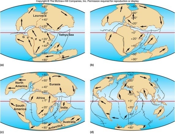
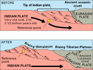
- About 200 million years ago India was a large island divided from the Gondwana plate lying in the southern hemisphere. Then it started drifting north in Tethys sea towards Eurasian plate at about 9 and 16 cm per year.
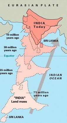
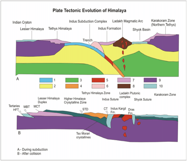
- At about 50 million years ago Indian plate started colliding with the Eurasian plate making the first contact in the western part (Indus Tsangpo suture zone).
- The various stages of this collision led to the formation of not only the three parallel ranges of the Himalayas but also the cause for the formation of Tibet plateau and the Gangetic plains in the northern India.
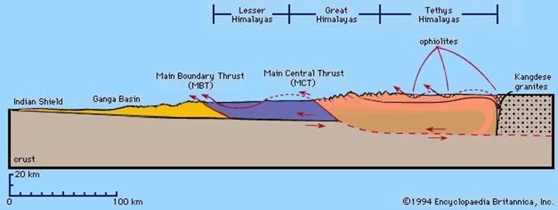
Stage 1:
- The sediments that settled on the Tethys sea floor got buckled up forming the trans-Himalayan ranges.
Stage 2:
- The ocean crust of Tethys sea got lifted up due to minor faults forming the roof of the world, The Tibetian plateau.
Stage 3:
- The continental slope part of Indian plate started to buckle up creating a parallel range of Greater Himalayas (Himadri). Also resulting in Malani fault to its north and main central thrust to its south.
Stage 4:
- Next, the continental shelf part of Indian plate folded forming the lesser Himalayas (Himachal) with a main central thrust to its north and main boundary fault to its south.
Stage 5:
- While the other ranges are being formed due to the collision of two plates against each other, a syncline (foredeep) is formed collecting sediments for thousands of years (due to Isostacy).
- This region later folded itself due to continued northward movement of Indian plate creating the Shiwaliks ranges.
- This created Himalayan frontal fault to its south as well.
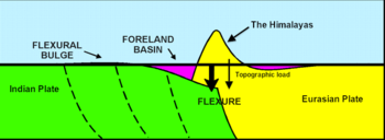
Stage 6: ( Current scenario)
- There is a syncline formed (foredeep) to the south of Shiwalik ranges which is collecting sediments since thousands of years(due to Isostacy), the region that we call today as the northern Ganga basin.
- This region is also estimated to turn into another parallel Himalayan range in sufficient geological time.
- The Himalayas are still rising by more than 1 cm per year as India continues to move northwards into Asia, which explains the occurrence of shallow focus earthquakes in the region today.
- However, the forces of weathering and erosion are lowering the Himalayas at about the same rate.
- The Himalayas and Tibetan plateau trend east-west and extend for 2,900 km, reaching the maximum elevation of 8,848 metres (Mount Everest – the highest point on Earth).