
Classification of Stratigraphic Sequences: Lithostratigraphic, Biostratigraphic, Chronostratigraphic and Magnetostratigraphic and Their Interrelationships
2.1. Lithostratigraphy and Lithostratigraphic Sequences
- Litho = rock, strata=layers.
- Lithostratigraphy: The element of stratigraphy that deals with the description and nomenclature of the rocks of the Earth based on their lithology and their stratigraphic relations.
- A lithostratigraphic unit- The body of sedimentary, extrusive igneous, metasedimentary, or metavolcanic rock strata which is distinguished and delimited on the basis of lithic characteristics and stratigraphic position.
- A lithostratigraphic unit generally conforms to the Law of Superposition and commonly is stratified and tabular in form.
- Lithostratigraphic classification: The organization of rock bodies into units on the basis of their lithological properties and their stratigraphic relations.
- The geographic extent of a lithostratigraphic unit is controlled entirely by the continuity and extent of its diagnostic lithological features.
Principle of Original Horizontality
- Layers of sediment are originally deposited horizontally under the action of gravity. It is a relative dating
- It was first proposed by the Danish geological pioneer Nicholas Steno(1638–1686).
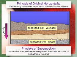
Fig. Principle of Original Horizontality
Formal and Informal Lithostratigraphic Units
- Formally units are those that are named in accordance with an established scheme of classification.
- Informal units whose unit terms are ordinary nouns, are not protected by the stability provided by proper formalization and recommended classification procedures.
Lithostratigraphic standard units are-
- Supergroup
- Group
- Formation
- Member
- Bed
Procedures for Establishing Lithostratigraphic Units
- A stratotypeor type section is a geological term that names the physical location or outcrop of a particular reference exposure of a stratigraphic sequence or stratigraphic boundary.
- Boundaries: Boundaries of lithostratigraphic units are placed at positions of lithologic change or arbitrarily within zones of vertical or lateral lithologic gradation or intertonguing.
- Boundaries of lithostratigraphic units commonly cut across time surfaces, across the limits of fossil ranges, and across the boundaries of any other kind of stratigraphic units.
- Unconformities and hiatuses: Stratigraphic sequences of similar lithologic composition but separated by regional unconformities or major hiatuses should be mapped as separate lithostratigraphic units.
Lithological Unit with Contrast to Indian Geology
- Supergroup- Vindhyans Supergroup
- Group- Semri group
- Formation- Kajrahat Limestone
- Member- Lower flat bedded limestone, the middle biohermal limestoneand the upper flat bedded
- Bed- Limestone, dolomite and shales beds.
- The Vindhyan basin is a sickle-shaped basin on the Bundelkhand-Aravalli Province which stabilized prior to 2.5 Ga (Eriksson et al., 1999).
- The Vindhyan Supergroup overlies a variety of Precambrian basement rocks including Bundelkhand Granite, Mahakoshal Group, Bijawar Group, Gwalior Group, Banded Gneissic Complex (BGC) and Chhotanagpur Gneissic Complex (CGC).
- The Semri Group is the oldest group of the Vindhyan Supergroup. The Semri Group in the Son Valley overlies the Bijawar Series of sediments and lavas, which contains volcanic rocks that Mathur (1981) correlates to the 1815 Ma Gwalior Volcanics.
|
Group |
Formations |
|
Bhander Group |
Dholpura Shale Balwan Limestone Maihar Sandstone Sirbu Shale Bundi Hill Sandstone Samaria Shale Lakheri Limestone / Bhander Limestone Ganurgarh Shale |
|
Rewa Group |
Upper Rewa Sandstone Jhiri Shale Lower Rewa Sandstone Panna Shale |
|
Kaimur Group |
Dhandraul Quartzite Scarp Sandstone and Conglomerate Bijaigarh Shale Susnai Breccia Upper Quartzite Lower Quartzite |
|
Unconformity Semri Group |
Rohtas Formation Kheinjua Formation/Chorhat Formatic Porcellanite Formation Kajrahat Limestone Basal Formation |
|
Bijawar Group |
Phyllites |
Fig. Lithological succession of Vindhyan Supergroup
2.2. Biostratigraphy and Biostratigraphic Sequences
- Biostratigraphyis the branch of stratigraphywhich focuses on correlating and assigning relative ages of rock strata by using the fossil assemblages contained within them.
- Aim - Correlation, demonstrating that a particular horizonin one geological section represents the same period of time as another horizon at some other section.
- The fossils are useful because sedimentsof the same age can look completely different because of local variations in the sedimentary environment.
Example-One section might have been made up of clays and marls while another has more chalky limestone, but if the fossil species recorded are similar, the two sediments are likely to have been laid down at the same time.
- Ammonites, graptolites, archeocyathids, trilobitesare index fossilsthat are widely used in biostratigraphy.
- Microfossils-acritarchs, chitinozoans, conodonts, dinoflagellatecysts, pollen, spores, ostracods and foraminifera are also frequently used.
Index fossils
- Index fossils(also known as guide fossils or indicator fossils) are fossils used to define and identify geologic periods (or faunal stages).
- Index fossils must have a short vertical range, wide geographic distribution and rapid evolutionary trends.
- Zone fossil is used when the fossil has all the characters stated above except wide geographical distribution, they are limited to a zone and can't be used for correlations of strata.
To be useful in stratigraphic correlation index fossils should be:
- Independent of their environment
- Geographically widespread
- Rapidly evolving
- Easy to preserve (Easier in low-energy, non-oxidized environment)
- Easy to identify
- Example: Archaocyathids (Lower Cambrian) (529 to 509million years ago)
Types of Fossil Assemblages
There are two types of fossil assemblages
Biocoenosis
- Biocoenosis is an assemblage representing the living assemblage of any particular environment.
- Natural assemblage reliable for biostratigraphy.
Thanatocoenosis
- It is an assemblage which undergone reworked and transportation.
- This assemblage cannot be used for age determination.
Biostartigraphic Events
Events that are utilized in biostratigraphy are-
- First appearance
- Last occurrence
- Rapid increase in population
- Rapid decline in population
Boundaries
- The boundaries of the biozones are drawn at surfaces that mark the lowest occurrence, highest occurrence, limit, increase in abundance or decrease in abundance of one or more components of flora and fauna.
- The base or the top of one kind of biozone may need not to be coincide with the base or the top of another biozone.

Terminologies
- Top horizon
- Extinction horizon,
- Last occurrences (LO),
- Last appearance datum (LAD),
- First downhole occurrence (FDO),
- First occurrence (FO),
- First appearance datum (FAD) and
- Last downhole occurrence (LDO).
Biozones
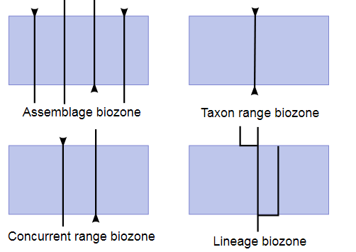
- The biozone is the fundamental biostratigraphic unit. Its thickness range from a few to hundreds of meters, and its extant range from local to worldwide. Biostratigraphic units are divided into six principal kinds of biozones.
- Five kinds of biozones are in common use: Range zones, interval zones, assemblage zones, abundance zones, and lineage zones.
- These types of biozones have no hierarchical significance, and are not based on mutually exclusive criteria. A single stratigraphic interval may, therefore, be divided independently into range zones, interval zones, etc., depending on the biostratigraphic features chosen.
Range Zone
- The body of strata representing the known stratigraphic and geographic range of occurrence of a particular taxon or combination of two taxa of any rank.
- There are two principal types of range zones:
- Taxon-range zone and
- Concurrent-range zone.
Taxon-range Zone
The lower, upper and lateral limits of this zone are determined by the range of occurrence of taxon a.
Definition
- The body of strata representing the known range of stratigraphic and geographic occurrence of specimens of a particular taxon.
- It is the sum of the documented occurrences in all individual sections and localities from which the particular taxon has been identified.
- The boundaries of a taxon-range zone in any one section are the horizons of lowest stratigraphic occurrence and highest stratigraphic occurrence of the specified taxon in that section.
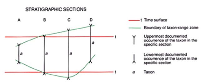
Concurrent-range Zone
The lower, upper and lateral limits of this zone are determined by the range of concurrent occurrence of taxa a and b.
Definition
- The body of strata including the overlapping parts of the range zones of two specified taxa.
- Two specified taxa are used to define the boundaries of the zone.
- A concurrent-range zone is named from both the taxa that define and characterize the biozone by their concurrence.

Interval Zone
Definition
- The body of fossiliferous strata between two specified biohorizons.
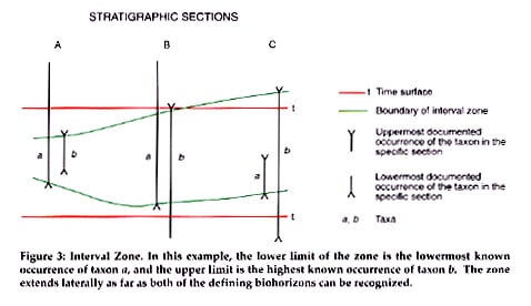
- Such a zone is not itself necessarily the range zone of a taxon or concurrence of taxa; it is defined and identified only on the basis of its bounding biohorizons.
- The lower limit of the zone is the lowermost known occurrence of taxon a, and the upper limit is the highest known occurrence of taxon b. The zone extends laterally as far as of the defining biohorizons can be recognized.
Interval Zone (Highest occurrence zone).
- This kind of interval zone is particularly useful in subsurface work.
- This type of interval zone has been called "last-occurrence zone" but should preferably be called "highest-occurrence zone".

Lineage Zone/Consecutive range zone
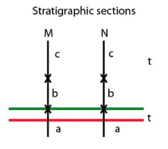
In A, the lineage zone represents the entire range of taxon b, from the highest occurrence of its ancestor, taxon a, to the lowermost occurrence of its descendant, taxon c.
Definition
- The body of strata containing specimens representing a specific segment of an evolutionary lineage.
- It may represent the entire range of a taxon within a lineage or only that part of the range of the taxon below the appearance of a descendant taxon.
- Lineage zones are the most reliable means of correlation of relative time by use of the biostratigraphic method.
Assemblage Zone
The assemblage diagnostic of the zone includes nine taxa with diverse stratigraphic ranges. For this assemblage zones to be useful, it may be necessary to provide some explicit description of its boundaries. For ex- The lower boundary can be said to be placed at the lowermost occurrence of taxa and g and upper boundary at highest occurrence of taxon c.
Definition
- The body of strata characterized by an assemblage of three or more fossil taxa that, taken together, distinguishes it in biostratigraphic character from adjacent strata.
- Boundaries-The boundaries of an assemblage zone are drawn at biohorizons marking the limits of occurrence of the specified assemblage that is characteristic of the unit.

Abundance Range Zone
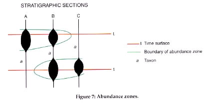
Definition
- The body of strata in which the abundance of a particular taxon or specified group of taxa is significantly greater than is usual in the adjacent parts of the section.
- Named for the most characteristic or diagnostic fossils in its assemblage.
- Boundaries- The boundaries of an assemblage zone are defined by the typical, specified fossil assemblage's occurrence: this can include the appearance, but also the disappearance of certain taxa.
Significance of biostratigraphy and its utility
- For correlation and age determination of sedimentary rocks.
- Paleontologists have traditionally used fossil data to provide information about the relative age, stratigraphic correlation, and paleoenvironment (notably paleobathymetry) of sedimentary strata.
- The chemical records preserved in sediments are not only an important indicator of paleo environmental change, but can also provide an alternative stratigraphy proxy.
- Microfossilsare used to determine how old a piece of rock is and determine if there is gas or oil in the area.
- They are also used to see what kinds of major geological events took place such as earthquakes or major weather changes such as ice storms.
- Biostratigraphy can play a role in reservoir characterization, correlation, and well site operations.
Summary of Biozones

2.3. Chronostratigraphy and Chronostratigraphic Sequences
Definitions
- Chronostratigraphic divisions are ‘time/rock’
- Chronostratigraphyis the element of stratigraphy that deals with the relative time relations and with the ages of rock bodies.
- Chronostratigraphic unitsare bodies of rocks, layered or not, that were formed during a specified interval of geologic time (the geochronologic units).
- The units of geologic time during which chronostratigraphic units were formed are called geochronologic units.
- A chronostratigraphic classificationis the organization of rocks into units on the basis of their age or time of origin.
Purpose: To systematically organize the rocks forming the Earth's crust into named units (chronostratigraphic units) corresponding to intervals of geologic time (geochronologic units) to serve as a basis for time-correlation and a reference system for recording events of geologic history.
- A chronostratigraphic horizon, or Chronohorizon/Marker horizon are stratigraphic units of such distinctive composition and appearance, that, despite their presence in separate geographic locations, there is no doubt about their being of equivalent age (isochronous) and of common origin.
- Such horizons can be used as the boundaries of a chronostratigraphic unit.
- Examples of chronostratigraphic markers in the Quaternary include tephras, magnetic polarity reversal horizons, and tektites.
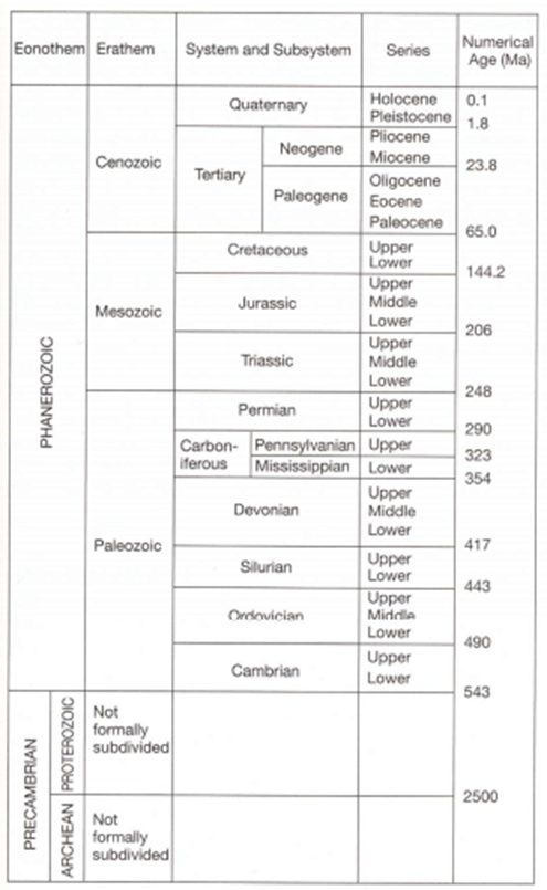
Chronostratigraphic Units
- Hierarchy of formal chronostratigraphic and geochronologic unit terms.

Example 1- An Erathem (like the Mesozoic) would contain several Systems (Triassic, Jurassic, Cretaceous); a System would contain several Series or Stages (the Cretaceous System would contain for instance, the Aptian and the Albian Stages).
Example 2-
- Eonothem – Phanerozoic
- Erathem – Paleozoic
- System – Ordovician
- Series – Upper Ordovician
- Stage – Ashgill
Stage (and Age)
- Basic working unit of chronostratigraphy.
- Very useful for intraregional and intracontinental classification & correlation.
- The stage includes all rocks formed during an age.
- A stage is normally the lowest ranking unit in the chronostratigraphic hierarchy
- It is a subdivision of a series.
Series (and Epoch)
- The series is a chronostratigraphic unit ranking above a stage and below a system.
- A system can be divided into two to six series. Example-Lower Jurassic series, Upper Jurassic series and Middle Jurassic Series.
- Used for chronostratigraphic and correlation worldwide and within provinces.
- The geochronologic equivalent of a series is an epoch.
System (and Period)
- Definition:A system is a unit of major rank in the conventional chronostratigraphic hierarchy, above a series and below an erathem.
- Example- Permian System, Jurassic System.
- The geochronologic equivalent of a system is a period. Occasionally, the terms subsystem and supersystem have been used.
- Name:The names of currently recognized systems are of diverse origin inherited from early classifications: some indicate chronologic position (Tertiary, Quaternary), others have lithological connotation (Carboniferous, Cretaceous), others are tribal (Ordovician, Silurian), and still others are geographic (Devonian, Permian).
Erathem (and Era)
- Subdivision of an eonothem.
- An erathem consists of a group of systems.
- The geochronologic equivalent of an erathem is an era.
- The names of erathem were chosen to reflect major changes of the development of life on the Earth: Paleozoic (old life), Mesozoic (intermediate life), and Cenozoic (recent life).
- Eras carry the same name as their corresponding erathems.
Eonothem (and Eon)
- Highest ranking chronostratigraphic unit.
- The geochronologic equivalent is an eon.
- Three eonothems are generally recognized, from older to younger, the Archean, Proterozoic and Phanerozoic eonothem (Paleozoic, Mesozoic and Cenozoic erathems). The combined first two is usually referred to as the Precambrian.
Nonhierarchical formal chronostratigraphic units –
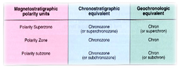
The Chronozone
- Smallest chronostratigraphic unit.
- Boundaries are independent of those of ranked stratigraphic events.
- It is the body of rocks formed anywhere during the time span of some designated stratigraphic unit or geologic feature.
- Defined by events such as geomagnetic reversals (magnetozones), or based on the presence of specific fossils (biozone or biochronozone).
- The corresponding geochronologic unit is the chron.
- A formal chronozone based on the time span of a biozone includes all strata equivalent in age to the total maximum time span of that biozone regardless of the presence or absence of fossils diagnostic of the biozone.
- A chronozone takes its name from the stratigraphic unit on which it is based, e.g., Exus albus Chronozone, based on the Exus albus Range Zone.

Fig. Relationship between Exus albus Chronozone and Exus albus Biozone (Distribution of Exus albus shown by dot-pattern)
Fig. Nomenclature of Phanerozoic chronostratigraphic units
Geochronology
- Geochronologyis the science of determining the age of rocks, fossils, and sediments using signatures inherent in the rocks themselves.
- Absolute geochronology can be accomplished through radioactive isotopes, whereas relative geochronology is provided by tools such as palaeomagnetismand stable isotope ratios.
- Geochronology: From largest to smallest:
Application of Geochronology
- Geochronologyis dating of earth materials, surfaces, and processes.
- Geochronology is essential for paleoseismology because it constrains dates of paleoearthquakes and average rates of fault displacement.
- The most useful geochronologic methods for paleoseismic investigations yield high-resolution ages for common, late Quaternary materials such as soils or buried flora and fauna (Lettis and Kelson, 2000).
- Geochronologyis an indispensable tool for reconstructing the geodynamic evolution of orogenic belts and can contribute substantially to determination of the paleogeographic affiliation of different metamorphic units.
- Geochronology has become one of the most essential tools in reconstructing processes of continental growth and evolution, and in situdating of minerals has become common practice through the development of high-resolution ion microprobes and laser ablation inductively coupled plasma mass spectrometry techniques.
- Geochronology includes the search for very old crustal remnants, the establishment of Precambrian supercontinents, reconstruction of magmatic and tectonic processes in accretionary orogens, verification of ancient high-pressure rocks, and the reconstruction of detailed metamorphic histories by dating minerals in their original textural settings.
2.4. Magnetostratigraphy and Magnetostratigraphic Sequences
- Magnetostratigraphy- The element of stratigraphy that deals with the magnetic characteristics of rock bodies.
- Magnetostratigraphic classification-The organization of rock bodies into units based on differences in magnetic character.
- Magnetostratigraphic unit (magnetozone)- A body of rocks unified by similar magnetic characteristics which allow it to be differentiated from adjacent rock bodies.
- Magnetostratigraphic polarity classification- The organization of rock bodies into units based on changes in the polarity of their remanent magnetization related to reversals in the polarity of the Earth's magnetic field.
- Magnetostratigraphic polarity unit- A body of rocks characterized by its magnetic polarity that allows it to be differentiated from adjacent rock bodies.
Magnetostratigraphic polarity-reversal horizons and polarity-transition zones
- Magnetostratigraphic polarity-reversal horizons are surfaces or thin transition intervals across which the magnetic polarity reverses.
- A magnetic polarity reversal is a change of the earth's magnetic field to the opposite polarity.
- Rocks created along the oceanic spreading ridges commonly preserve this pattern of polarity reversals as they cool, and this pattern can be used to determine the rate of ocean ridge spreading.
- Magnetostratigraphic polarity-reversal horizons and polarity-transition zones provide the boundaries for magnetostratigraphic polarity units.
Kinds of magnetostratigraphic polarity units
- The basic formal unit in magnetostratigraphic polarity classification is the magnetostratigraphic polarity zone, or simply polarity zone.
- Polarity zones may be subdivided into polarity subzones.
- Magnetostratigraphic polarity zones may consist of bodies of strata unified by:
- A single polarity of magnetization;
- An intricate alternation of normal and reversed polarity of magnetization;
- Having dominantly either normal or reversed polarity, but with minor intervals of the opposite polarity.
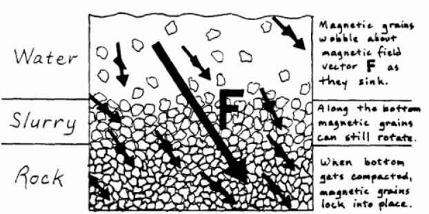
Remnant magnetism:
- Remanence or remanent magnetization or residual magnetism is the magnetization left behind in a ferromagnetic material after an external magnetic field is removed.
- A rock's intrinsic magnetic field that forms in alignment with Earth's magnetic field when the rock forms. This can happen in three ways:
Thermal remanent magnetization (TRM)
- TRM (thermoremanent magnetization) occurs when a substance is cooled, in the presence of a magnetic field, from above its Curie temperature to below that temperature.
- Many minerals that solidify from magma (e.g. hematite and magnetite) acquire an intrinsic magnetic field once they cool past their Curie point(~650° C for hematite, ~578°C for magnetite). This field forms in alignment with Earth's magnetic field.
- Once the Curie point is reached, the mineral's intrinsic field keeps the same orientation regardless of what the Earth's field does.
Detrital remnant magnetization (DRM)
- When magnetic minerals are present in silt and clay being deposited in low energy environments (like deep lakes) they align themselves with the Earth's magnetic field while still in suspension.
- The resulting sediments then have an intrinsic magnetic field that is aligned with Earth's field at the time of deposition.
Chemical remanent magnetization (CRM)
- Chemical remanent magnetism (CRM) is imparted to ferro‐ and ferrimagnetic minerals by chemical processes, at temperatures below their Curie points, in the presence of an effective magnetic field.
- CRM (chemical, or crystallization, remanent magnetization) can be induced after a crystal is formed and undergoes one of a number of physicochemical changes, such as oxidation or reduction, a phase change, dehydration, recrystallization, or precipitation of natural cements.


Properties of TRM, DRM and CRM
Geomagnetic Reversals
- A geomagnetic reversalis a change in earth’s magnetic field such that the positions of magnetic north and magnetic south are interchanged (not to be confused with geographic north and geographic south).
- The primary remanent magnetic polarity of rocks can be either:
- Normal: Magnetic north coincides roughly with geographic north.
- Reversed: Magnetic north coincides roughly with geographic south.
- The record of these reversals is preserved in ocean floor basalt, which both:
- Retains a strong remnant magnetic field and
- Generated at roughly constant rates, allowing the relative durations of intervals of similar polarity to be determined.


- At various times in the past, the magnetic field was oriented in the opposite direction, and compasses would have pointed toward magnetic south.
- These time periods were ones of reverse polarity.
- New oceanic crust inherits the Earth’s magnetic field at the time it solidifies.
- Reversals of the Earth’s magnetic field produce magnetic anomaliesor variations in the magnetic character of the oceanic crust.
- Thus the sea floor has regions where its magnetic minerals point north (normal) and areas where they point south (reverse).
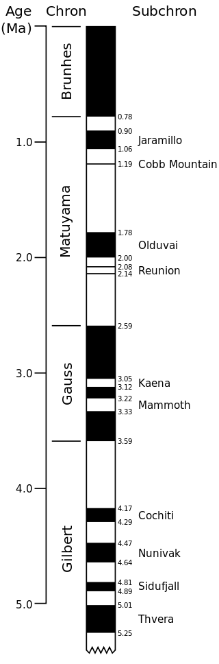
Geomagnetic polarity during the last 5 million years (Pliocene and Quaternary, late Cenozoic Era). Dark areas denote periods where the polarity matches today's normal polarity; light areas denote periods where that polarity is reversed.
2.5. Interrelationships Between Litho, Chrono, Bio, Magneto units of Stratigraphy
The Interrelationships
- The categories within stratigraphic classification are all closely related. All deal with the rocks of the Earth's crust, with the picture of the stratified Earth as it presently exists, and with the history of the Earth as interpreted from its rocks.
- Each category, however, is concerned with a different property or attribute of the rocks and a different aspect of Earth history.
- The relative importance of the different categories varies with circumstances. Each is important for particular purposes.
- Lithostratigraphic units are the basic units of geologic surface or subsurface mapping, and lithostratigraphic classification is usually the first approach in stratigraphic work in any new area.
- Wherever there are rocks, it is possible to develop a lithostratigraphic classification even when no other stratigraphic procedures are feasible.
- Lithostratigraphic units are based primarily on the lithologic properties of rocks—sedimentary, igneous, and metamorphic.
- The fossil content of lithostratigraphic units may in certain cases be an important distinguishing element in their recognition, not because of the age significance of the fossils but because of their diagnostic lithologic (physical) properties. Coquinas, algal reefs, radio-larites, oyster beds, and coal beds are good examples.
- Each lithostratigraphic unit was formed during a specific interval of geologic time, it has not only lithologic significance but also chrono-stratigraphic significance.
- The concept of time, however, properly plays little part in establishing or identifying lithostratigraphic units and their boundaries. Lithologic character is generally influenced more strongly by conditions of formation than by time of origin; similar rock types are repeated.
- The categories within stratigraphic classification are the rocks of the Earth's crust, with the picture of the stratified Earth, and with the history of the Earth as interpreted from its rock bodies.
- Each category, however, is concerned with a different property or attribute of the rocks and a different aspect of Earth history. The relative importance of the different categories varies with the circumstances. Each is important for particular purposes.
- Lithostratigraphic units are the basic units of geologic mapping. Wherever there are rocks, it is possible to develop a lithostratigraphic classification. Lithostratigraphic units are based on the lithologic character of rocks.
- Fossils may be an important distinguishing element in their recognition, but only because of their diagnostic lithologic characterization.
- Lithologic character is influenced more strongly by conditions of formation than by time of origin; nearly identical rock types are repeated time and again in the stratigraphic sequence, and the boundaries of almost all lithostratigraphic units cut across synchronous surfaces when traced laterally.
- Biostratigraphic classification is also an early step in working out the stratigraphy of a region. Biostratigraphic units are based on the fossil content of the rocks.
- The selection and establishment of biostratigraphic units are not determined by the lithologic composition of the strata, except that the presence or absence of fossils and the kind of fossils present, may be related to the type and lithofacies of the rocks in which they are found.
- Biostratigraphic units are distinct from other kinds of stratigraphic units in that the organisms whose fossil remains define them show evolutionary changes through geologic time that are not repeated in the stratigraphic record.
- This makes the fossil assemblages of any one age distinctive from any other.
- Lithostratigraphic and biostratigraphic units are fundamentally different kinds of stratigraphic units based on different distinguishing criteria.
- Their boundaries may coincide locally, but commonly they lie at different stratigraphic horizons or cross each other.
- Whereas lithostratigraphic classification is possible for anybody of rock, biostratigraphic classification is possible only for fossiliferous rocks that bear identifiable fossils.
- Both lithostratigraphic and biostratigraphic units reflect the environment of deposition, but biostratigraphic units are more influenced by, and indicative of, geologic age.
- They are also less repetitive in character because they are based on irreversible evolutionary change.
- Lithostratigraphic and biostratigraphic units are indispensable objective units, essential in picturing the lithologic constitution and geometry of the rocks of the Earth's crust and the development of life and past environments on the Earth.
- Unconformity-bounded units and magnetostratigraphic polarity units, like biostratigraphic units, can be established only when the diagnostic properties on which they are based are present in the rocks.
- Unconformity-bounded units may include a number of other kinds of stratigraphic units, both in vertical and lateral succession.
- Similarly, an unconformity-bounded unit may represent all or parts of several chronostratigraphic units. In special cases, the boundaries of an unconformity-bounded unit may coincide with the boundaries of other kinds of stratigraphic units.
- However, the boundaries of unconformity-bounded units are always diachronous to a lesser or greater extent, and so never correspond with the boundaries of chronostratigraphic units.
- Magnetostratigraphic polarity units while similar to lithostratigraphic and biostratigraphic units in that they are based only on a directly determinable property of the rocks, their magnetic polarity, are different from them because magnetostratigraphic polarity units are potentially recognizable globally and, in this respect, they are similar to chronostratigraphic units.
- The changes in magnetic polarity are the result of very rapid worldwide reversals of the Earth's magnetic field, generally occurring through a time span of no more than about 5,000 years.
- The magnetic-polarity-reversal horizons produced as a result of these events do not, therefore, constitute synchronous horizons.
- Consequently, the body of rocks lying between magnetic-polarity reversals horizons produced by two successive polarity reversals constitutes a polarity unit containing everywhere strata representing essentially, but not exactly, the same time span.
- Such units may closely approximate chronostratigraphic units, but they are not chronostratigraphic units because they are defined primarily not by the record of time but by a specific physical character, the change in the polarity of remanent magnetization, which is not instantaneous.
- Although magnetostratigraphic-polarity horizons and units may be useful guides to chronostratigraphic position, they have relatively little individuality, one reversal looks like another, and can usually be identified only by supporting age evidence, such as paleontologic or isotopic data.
- Chronostratigraphic units are defined as encompassing all rocks formed within certain time spans of Earth history regardless of their compositions or properties.
- By definition, these units everywhere include rocks of only a certain age and their boundaries are everywhere synchronous. This is in contrast with lithostratigraphic units that can be objectively recognized wherever there are rocks, and with biostratigraphic, magnetostratigraphic polarity, and unconformity-bounded units that are limited by the occurrence of specific properties or attributes of the rocks.
- Whereas other kinds of stratigraphic units are distinguished, established, and identified on the basis of observable physical features, chronostratigraphic units are distinguished, established, and identified on the basis of their time of formation-an abstract character-as interpreted from these observable properties.
- Biostratigraphic units may approximate chronostratigraphic units even over wide areas, but the boundaries of biostratigraphic units may diverge from those of a chronostratigraphic unit for many reasons.
- Principal among these are changes in depositional facies, variations in conditions for fossilization and preservation of fossils, vagaries of fossil discovery, and biogeographic differences. Biostratigraphic units cannot be recognized in rocks where there are no fossils.
- Some lithostratigraphic units are excellent guides to approximate time correlation over large areas, as in the case of volcanic ash beds, but they, like biostratigraphic units, are not chronostratigraphic units because they are not bounded everywhere by synchronous surfaces.
- Unconformity-bounded units and magnetostratigraphic polarity units also provide valuable support for the development of chronostratigraphic classification.
- Especially, the boundaries of magnetostratigraphic polarity units because they record the very rapid reversal of the Earth's magnetic field, approach synchronous surfaces closer than any other kind of objective stratigraphic unit.
- If properly identified, they offer a sound foundation for global time correlation and chronostratigraphic classification.
- Chronostratigraphic classification stands out as the basis to reach the ultimate goal of stratigraphy.
- Chronostratigraphic units, as divisions of rock bodies based on geologic time, are in principle worldwide in extent, and important in providing a worldwide basis for communication and understanding.
- The above-mentioned kinds of stratigraphic units and their corresponding fields of stratigraphic investigation are the most commonly used.
- Thus, we may find it useful to recognize stratigraphic units or horizons based on electric-log characters, seismic properties, chemical changes, stable isotope analyses, or any of many other properties of rock bodies.
Difference between rock-stratigraphic units (left) and time-stratigraphic units (right).
- In this illustration the rock stratigraphic units, along with their lithostratigraphic correlation, are scaled to stratigraphic thickness, as they would be observed in a field study.
- When these same sections are portrayed as time-stratigraphic units (and organized according to the time intervals over which they were deposited), however, the character of their comparative relations (both inter-sectional and intra-sectional, as well as their inter-section correlations, change.
